Weather extremes are expected across Australia in early February, with snow conditions in the south, storms in the north and heatwaves in the east and west.
Subscribe now for unlimited access.
or signup to continue reading
An unseasonal cold snap pushing across southern Australia will end summer barbeque plans around Hobart, Melbourne, Adelaide and Canberra this weekend, according to the Bureau of Meteorology (BOM) forecasts.
South-east Australia will experience maximum temperatures 10-16 degrees below the February average.
Temperatures dipped low enough to see snow covering Victoria's skiing hotspots, Mount Buller and Mount Hotham, as well as some alpine areas in NSW.

The slopes are forecast for rain through the day, turning into snow in the afternoon and evening on Thursday February 2.
The snowy conditions are expected to continue through the weekend.
A severe weather warning should deter ocean swimmers in parts of Victoria, with damaging surf expected.
A sheep grazier warning has also been issued for parts of Victoria, NSW and Tasmania.
IN OTHER NEWS:
Sydney will benefit from the fresh weather, with westerly winds expected to reduce humidity after a record wet summer.
Sydney's weekend temperatures are forecast around 30 degrees with minimal cloud cover and a light breeze.
North of Sydney, temperatures are set to climb.
Grafton in northern NSW is forecast to reach 38 degrees on Friday, and expect humidity.
North-east NSW could see severe thunderstorms, with potentially damaging winds and large hail.
Hot, gusty winds could push temperatures in north-east NSW and south-east Queensland into the high 30s and low 40s.
These conditions are elevating fire caution, with some parts of NSW flagged as extremely dangerous.

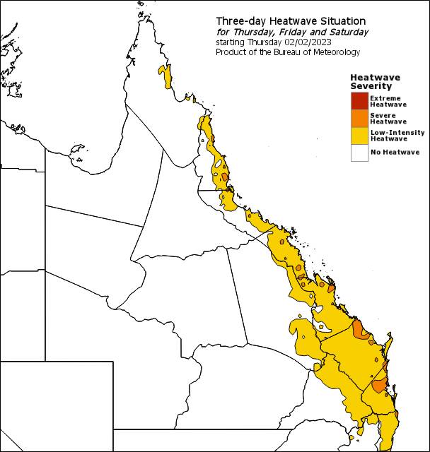
The BOM has issued low-intensity and severe heatwave warnings along the eastern coast of Queensland, with humidity accompanying days above 30 degrees.
Queensland's electricity demand is expected to hit record heights as temperatures over 30 degrees and thick humidity plague the state.
The Australian Energy Market Operator said Queensland will likely see a peak demand of 10,500 megawatts by 5.30pm Saturday February 3.
Queensland's previous electricity demand record was set in March 2022 with 10,085 megawatts.
Rainfall in Queensland's coastal north could reach 100 millimetres over several days.
Tropical inland Queensland and the NT could reach 200 millimetres in rainfall, with the monsoon trough strengthening into early next week.
Margaret River and Perth Hills are warned of high to extreme fire danger in coming days, along with some other parts of the state.
Temperatures in Western Australia soar into the high 30s, with days over 40 degrees expected in the state's west.


